We had a fun time over the Summer of 2011 once Derek recovered from the trauma of breaking his wrist. Brundage is a really cool place to ride, lift assisted. They have all kinds of trails, camping in the area. Music festivals, MTB races. It is a riding paradise in the summer. Miles of trails all over the place. Rode with Brian and Mandi, but didn't ride the DH trails they did. We had the fun on the cross country trails.
Friday, December 30, 2011
Wednesday, August 17, 2011
McKenzie River Trail
So we went for a ride in Oregon. My first trip there ever. It was entertaining.
We drove from Boise, Idaho to Blue River, Oregon. We stayed in a clean place, not the best place and definitely not the worst place we have stayed at on our mountain biking adventures.
We saw a special on Living Social for three nights and two days of shuttled mountain biking the McKenzie River Trail. Before I get ahead of myself, I have to say, the place was okay, but I would recommend this other place we saw a little closer to the lower trailhead that looked a bit nicer. Cabins on the River was the name of that place or some thing like that. The other thing that I would also say is the place we did stay at does offer shuttle services regardless of where you stay.
I do recommend staying in a cabin, cottage, camper or such if you do this ride. Reason being, this ride is tough. You will want a hot shower, ability to make a delicious dinner (ie a kitchen) and a nice bed when the you have finished eating and your eyelids start getting heavy. You will definitely of earned a nice relaxing evening.
Now on to the trail and the scenery....

We dropped our car off at the end of the trail near the McKenzie River Ranger Station and the shuttle took us to the upper trailhead a few miles from Clear Lake. We checked our bikes over one more time, got our gear on and started down the trail.

The first thing that the trail does is heads over a bridge, but there isn't any water under it, just a lava rock river bed that is dry.
Then the fun begins and you are entering the old growth forest on a rolling trail.
After a couple of miles you find yourself at an intersection and you have to decide which way you want to go around Clear Lake.
Here is where we checked out the trail that goes around to the lava side of Clear Lake and made the decision to go on the "resort" side.

From what we could see and what people told us the lava side is not a fun direction to ride. The lava side of the lake as it finishes going around the lake is paved. We hike the paved path the next day, it is only about 18 inches wide and it does not look very fun to ride, trust me when I say that.

After the lake you cross US Route 20. This is the only place the trail crosses the main route. You then have to take the trail on the right side of the river. This goes over some rough terrain through here and there are a few hike a bike sections.
The good thing though about this is that the trail passes some of the more spectacular scenery while on the McKenzie River Trail. You ride past Sahalie Falls as seen to the left here. This waterfall is approximately a 120 ft. fall. The mist in the area is refreshing and makes the hike-a-bike sections very doable.

And Koosah Falls is the next falls along the trail, it's approximately 90 ft tall.
To get to the falls you have to go over a few obstacles....


But then you get to finally see Koosah Falls. It is worth the ride that is for sure!
There is another set of waterfalls and many rapids along the route. The mist is keeping the temperatures down, that and those tall trees of the old growth forest that is surrounding you along the way.
The section along the waterfalls is really rough and unridable to most people, myself and Derek included. After the falls you pass Carmen Reservoir and then head off into some rolling terrain. This gives away back to a lava field, which is rideable in many places for good stretches. As you get closer to the Blue Pool (aka Tamolitch Pool) the trail is very technical and the lava is unforgiving if you fall. I was wishing that Derek and I were able to find elbow and knee guards for riding this section.
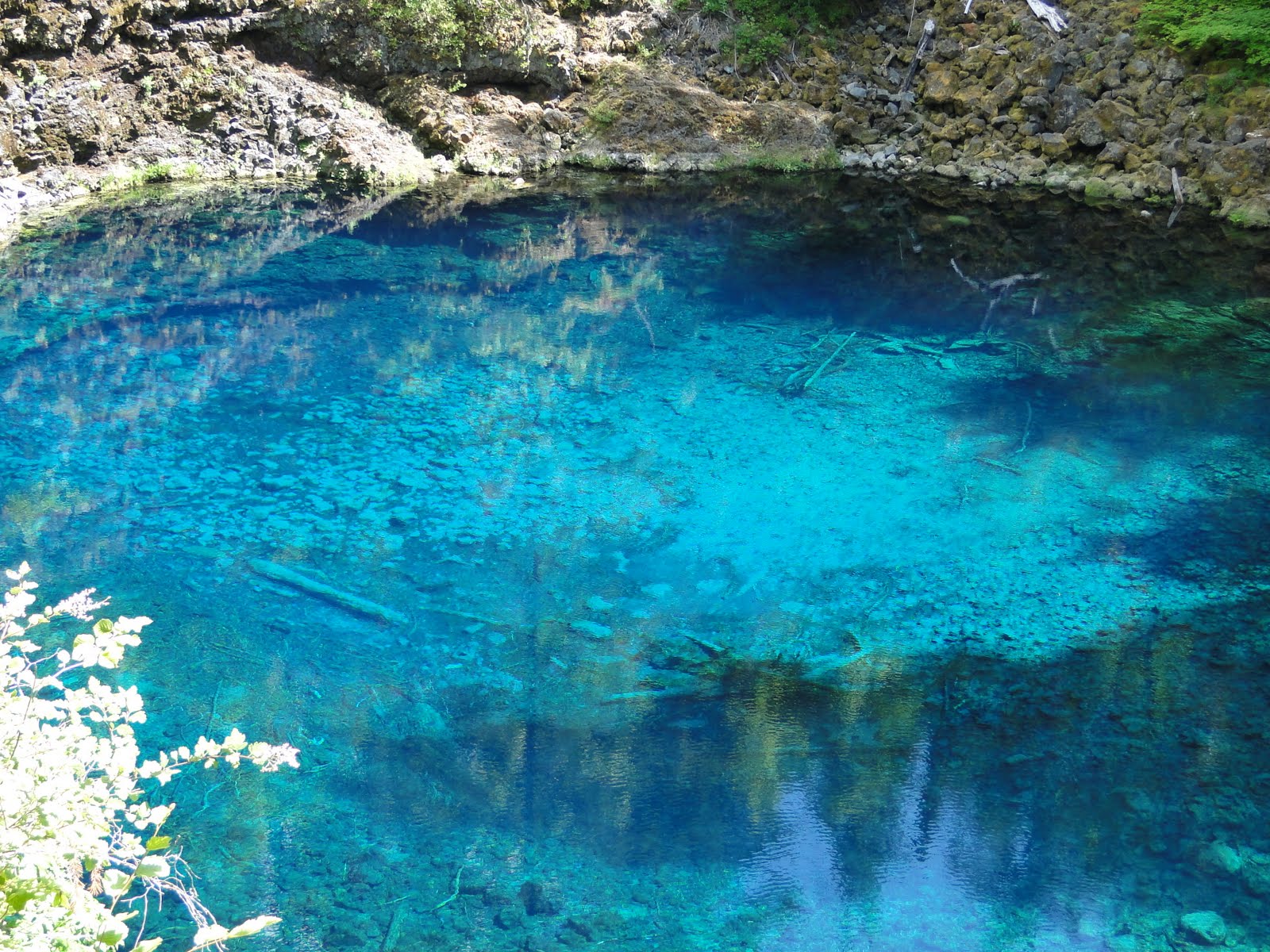
The Blue Pool is 36 degrees. The water is amazingly clean and clear. It is a pool at the bottom of what should be the river flowing over a cliff, however the water surfaces up from below, the river went underground till here.
For about a little less than a mile after the pool this ride is more of a hike.

Then the trail becomes this roller coaster that you pick up speed and the permanent grinning begins as you fly through the woods. There are still rocks and roots to go over, logs and bridges too, but from here on out it is rolling green woods and fun.
We failed to take pictures from this point on because we gave in to the urge to enjoy the speed. After the pool and this picture you cross Deer Creek and a few dirt roads that go through the woods.
Belnap Springs are the next point that you pass, if you want to go to the springs it is not on the trail, you have to take a detour to the springs. From what I have read they are not that great to see and are not that warm, but I don't know for certain any of this information is true since we didn't take a side trip to them.

At this point there are some more log bridges to cross before you finish the 26.5 mile ride. You end at your car that you left that morning. For us the ride took 6 hours to finish. We were tired by the end. Was it worth it? Absolutely! Would we do it again? Heck yeah! If you go, pack lots of snacks and a lunch. Bring lots of water and make sure that you drink it! You'll need it all!
If you go let me know what you think of the ride!
Tuesday, April 19, 2011
Saturday, October 16, 2010
Greenhorn Gulch and Imperial Gulch Trails (August 17, 2010)

Greenhorn Gulch, the start of the trail. It looks innocent from this point of view. Little do you realize how high you are to begin with, and much you are going to climb from this point of view. The trailhead started at over 5,000ft and climbed to just over 7,000ft.
This view is from the parking lot for the trailhead. This trail is not very far from town and yet you do not see anything but the trail and the mountains, very cool place.
 This trailhead area is where multiple trails begin and end. We had to cross the creek here in the beginning multiple times before it started to climb up, up, and up...
 We had stopped in to the local bike shop and they recommended these trails and we were glad we listened to their advice.
This trail system, like many in the area, is multi-user friendly. Which includes allowing motorcycles on the trail system. This might not sound like a good thing, but the motorcyclist actually play a huge role in maintaining many of the trails here in Idaho.
 We stopped for a snack and a map check here at the point where the three main trails in this area meet up. Greenhorn, Imperial and Mahoney Gulch Trails. The map was a little bit deceptive, we thought that at this point that there was only a little bit of climbing left, but oh no...
 And trust me I was tired here from the climbing, and hoping that the hills were going to relent to the anticipated downhill fun.
So we get out from the trees and looked around to see what looked like an easy section of the trail, before what we thought was the ascent. Derek was tired, but the trail being so much fun took his mind off of that!

This was me...

Before...
 And then this climb showed up... It was not a horrible climb, but the trail was really sandy in this section, making a hill climb like this into a hike-a-bike section.
It wasn't bad to begin, but I only made it a little further before I lost traction and had to step off the bike.
 Oh how sweet the downhill was though when it started. At that point unfortunately the pictures stopped, because of the fun we were having! We went down Imperial Gulch, and about a couple of miles from the end crossed back over to Greenhorn Gulch. Which meant that there was a little climb at the end, but worth it.
 Oh how sweet the downhill was though when it started. At that point unfortunately the pictures stopped, because of the fun we were having! We went down Imperial Gulch, and about a couple of miles from the end crossed back over to Greenhorn Gulch. Which meant that there was a little climb at the end, but worth it.
Our Camp at East Baker Creek (August 16 - 20, 2010)
 We were so lucky to find a great camp at the convergence of East Baker Creek and Baker Creek. This was between Stanley and Sun Valley, Idaho. We were a little paranoid about bears and brought Bear Pepper Spray. There were bears sited in the area. A friend of ours was here a couple of weeks before us and saw one only a couple of miles from our campsite.
Mountain bikers were riding by the entire time we were camping here. There were a couple of trails in the area, but we had an agenda and we stuck to it! Next time we return we might check out the trails near camp. We rode Fisher Creek Trail, Warm Springs Trail (at the Sun Valley Ski Resort) and Greenhorn Gulch Trail. There are just so many trails in the area, we are going to have to return for more adventures in the future.
Right next to our spot (5 feet behind the tent) was Baker Creek, soothing sounds to sleep next to. The creek was really cold, not something that I would jump in.
 The temperatures during the day were perfect, in the 70s. The nights were a little chilly (in the 40s) but I think that it is easier to sleep when it is a little chilly. The views were amazing, still some snow on some of the peaks that we could see from the camp.
The best part about this camp though was the hot spring that was only a couple of miles away. Every night we went and soaked away our aches and pains from the rides. It was warm, but not HOT, so it was very comfortable to soak in. No one else ever showed up while we were in it. The spot was just off the main state route in the area. It was free too which is nice. There were other hot springs closer to Sun Valley that were close to camp, but charged fees to access and my guess is that there would have been more people to have to share the pool with.
Our Trip to Sun Valley August 16 - 20, 2010

We decided on my break from school to go to Sun Valley for a few days. We had never been there before, it was amazing. We drove from Boise to Stanley, then on to our camping area near Baker Creek. Stopping along the way to look at the amazing Stanley Lake, Red Fish Lake and some amazing views along the way...
Tuesday, July 27, 2010
Adventures in Boise

Bogus Basin, The Face Trail. It is an awesome view of Boise from up here. The trail is really fun either way you ride it. It was nice to get out of the heat in Boise. The local biking group made the Deer Point Trail up to this trail. They also made a new trail called Fat Tire Traverse. I have to go back and ride that trail. It is really nice being in the trees! We are going to come up here to ride the trails in August when they have the lifts open. It will be a lot of fun!

Subscribe to:
Posts (Atom)